NOAA’s latest winter outlook shows where wetter-than-normal conditions are favored as a potentially historic El Niño strengthens.
Winter is still a few months away, but a new map from the National Weather Service’s Climate Prediction Center is giving Americans an early look at which parts of the country could be in for a particularly wet season.
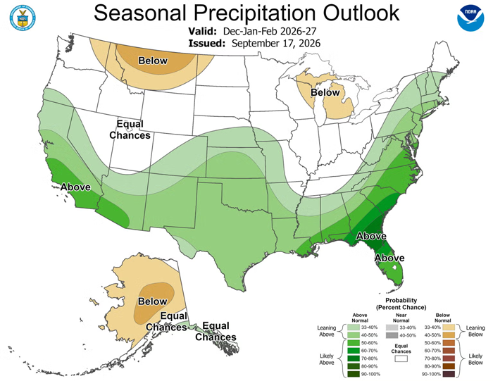
NOAA released its latest seasonal outlook on Sept. 17, including a precipitation map for December 2026 through February 2027. The outlook favors wetter-than-normal conditions across a broad stretch of the United States, including California, the Southwest, southern Plains, Gulf Coast and Southeast, with the wet pattern extending northward along much of the East Coast.
And a strengthening El Niño could have a lot to do with it.
Where Could the U.S. See the Most Rain and Snow This Winter?
The biggest precipitation signal on NOAA’s winter map is across parts of the Southeast.
During the winter months, NOAA says the chances for above-normal precipitation climb to 70 to 80 percent across southern Georgia and northern Florida. Wetter-than-normal conditions are also favored across the southern Plains, where probabilities reach 40 to 50 percent.
California is another area to watch.
The odds favoring above-normal precipitation increase as winter arrives, reaching 50 to 60 percent near the California coast during the December-January-February period. The wetter pattern could extend as far north as central Oregon, according to the Climate Prediction Center.
The wet signal also stretches across southern and central portions of the country and northward along the Atlantic Coast into New England. NOAA says that pattern is associated in large part with the expected position of the subtropical jet stream and storm track during El Niño.
Of course, more precipitation doesn’t automatically mean more snow.
NOAA’s map forecasts the chances of above-, near- or below-normal total precipitation, rather than snowfall specifically. Whether that precipitation falls as rain, snow or a wintry mix will depend on temperatures and individual weather systems as they develop.
The outlook also doesn’t mean every location shaded for above-normal precipitation will have a wet or snowy winter. Seasonal outlooks describe how the odds are tilted over a three-month period rather than forecasting individual storms.
A Potentially Historic El Niño Is Strengthening
There’s another reason this winter is drawing attention.
El Niño is already present and continuing to strengthen, and NOAA now puts the chance of a very strong El Niño this fall and winter at greater than 90 percent.
Even more striking, forecasters say there is a 75 percent chance that El Niño reaches a level during October through December that would exceed previous events in NOAA’s record dating back to 1950.
A stronger El Niño increases the chances of seeing weather patterns commonly associated with the climate phenomenon, but NOAA stresses that those impacts aren’t guaranteed.
The agency’s winter precipitation forecast leans heavily on historical El Niño patterns as well as current computer-model guidance. For late fall through early spring, NOAA describes the wet pattern across the southern and central United States and along the Atlantic Coast as the “dominant precipitation signal” for the season.
Not everyone is leaning wet, however. Parts of the interior Northwest and Great Lakes have modestly increased chances for below-normal precipitation through the winter, while much of Alaska is also favored to be drier than normal during the December-through-February period.
And this outlook isn’t set in stone. NOAA issues updated 90-day outlooks every month, with the next update scheduled for Oct. 15, giving forecasters another month’s worth of observations and model data before winter gets underway.
Copyright PARADE. All rights reserved. From https://parade.com. By Andrea Reiher.